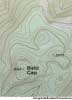
contour map
n.
A map showing elevations and surface configuration by means of contour lines.
American Heritage® Dictionary of the English Language, Fifth Edition. Copyright © 2016 by Houghton Mifflin Harcourt Publishing Company. Published by Houghton Mifflin Harcourt Publishing Company. All rights reserved.
con′tour map`
n.
a topographic map on which the shape of the land surface is shown by contour lines, the relative spacing of the lines indicating the relative slope of the surface.
[1860–65]
Random House Kernerman Webster's College Dictionary, © 2010 K Dictionaries Ltd. Copyright 2005, 1997, 1991 by Random House, Inc. All rights reserved.
contour map
A map that shows elevations above sea level and surface features of the land by means of contour lines.
The American Heritage® Student Science Dictionary, Second Edition. Copyright © 2014 by Houghton Mifflin Harcourt Publishing Company. Published by Houghton Mifflin Harcourt Publishing Company. All rights reserved.
ThesaurusAntonymsRelated WordsSynonymsLegend:
| Noun | 1. |  contour map - a map having contour lines through points of equal elevation contour map - a map having contour lines through points of equal elevationmap - a diagrammatic representation of the earth's surface (or part of it) |
Based on WordNet 3.0, Farlex clipart collection. © 2003-2012 Princeton University, Farlex Inc.